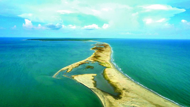
Adam’s Bridge is a chain of shoals stretching roughly 29 km between Dhanushkodi, on India’s Rameshwaram Island, and Talaimannar, on Sri Lanka’s Mannar Island. It sits mostly out of sight. Research using NASA’s ICESat-2 satellite found that 99.98 percent of its volume lies submerged in shallow water, leaving only a fraction of sandbanks exposed above the surface.
more
What it is made of
The ICESat-2 study put the total volume of Adam’s Bridge at about 1 cubic kilometre. NASA describes it as a chain of limestone shoals, and nineteenth-century British surveys found sand extending down 7 to 9 metres before reaching a harder base of coral reef or calcareous sandstone. The sandbanks are loose and fine, and none of them carries rock or vegetation.
The structure separates two bodies of water. To its north lies Palk Bay and the Palk Strait, a shallow channel with an average depth of 9 to 12 metres that narrows to about 53 km wide at its narrowest point. To the south lies the Gulf of Mannar, a UNESCO-recognised Marine Biosphere Reserve whose seafloor drops to 2,280 metres. Twice-yearly monsoon winds reverse the currents on either side, which is why the sandbanks shift position over time.
Whether it was once a land bridge
NASA’s photojournal describes Adam’s Bridge as a former land bridge. It says the crossing was passable on foot as late as the 15th century, and that storms afterwards broke it apart, though the bridge’s geologic origin remains disputed among researchers. A separate NASA image caption notes that some data suggests the shoals are the remnant of a true land connection that once ran between the two countries.
During the nineteenth century, British surveyors investigated the ridge, drilling test bores and mapping its structure. They were assessing whether it could be dredged to shorten shipping routes around Sri Lanka, and whether a railway line could cross it between Dhanushkodi and Mannar Island. Neither the dredging scheme nor the railway was built, but the bore data from those surveys is what later research used to work out what the ridge is made of.
How satellites replaced the bore survey
Modern measurements of Adam’s Bridge come from space rather than from a drill. NASA’s Terra satellite carries an instrument called ASTER, which images the Earth’s surface in 14 spectral bands, from visible light to thermal infrared, at a resolution of 15 to 90 metres. An ASTER image acquired on 25 March 2020 captured an area of Adam’s Bridge measuring 39.6 by 61.7 km.
The more detailed picture came later, from a satellite built for an entirely different purpose. ICESat-2 carries a green laser designed to profile ice sheets, but the same laser can register the returning photons of light that reach the seafloor to a depth of about 40 metres. Researchers gathered roughly 200,000 of those photons over Adam’s Bridge and used them to build a bathymetric model with a resolution of 10 metres, fine enough to map the ridge’s slopes, contours and volume in three dimensions rather than guessing from surface sand alone. That model is what showed the marked asymmetry in the ridge’s underwater slopes, evidence that water pushes more forcefully against it from the Gulf of Mannar side than from the Palk Strait.
Why the name persists
Adam’s Bridge is also known as Rama’s Bridge, a name tied to the Hindu tradition that Lord Rama built it during his travels through the region. The name has stayed attached to the feature even as satellite instruments have taken over from nineteenth-century bore surveys as the way to study it. NASA’s Aqua satellite has photographed the Palk Strait’s waters swirling with river sediment and phytoplankton, a reminder that the strait around the ridge is still an active, shifting system rather than a fixed one.