Saddleworth grew in three steps. Hillside weavers came first, then turnpike roads in the 18th century pulled them down into valley villages, and the Huddersfield Narrow Canal and the railway turned those villages into mill towns. A visitor today walks through all three steps at once, from the moorland routes down to the canal at Uppermill.
more
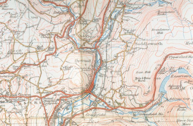
The district is a civil parish of a dozen or so settlements on the western slope of the Pennines. The river Tame and its side streams drain the eastern half, past Denshaw, Delph, Dobcross, Diggle, Uppermill and Greenfield. The river Medlock drains the western half, past Scouthead, Austerlands, Grasscroft, Lydgate, Grotton and Springhead.
A Yorkshire parish on the Lancashire side
Every spring, stream and river on this side of the Pennines runs west. Locally the water flows into the Tame, which joins the Goyt at Stockport to form the Mersey and reach the Irish Sea at Liverpool. For about ten centuries it belonged to the West Riding of Yorkshire instead, governed from Wakefield.
That mismatch is the first thing to understand about the place. Large stretches of the north and east of the parish sit more than 1,000 feet above sea level. The parish council says Saddleworth has long looked east to Huddersfield, Halifax and Leeds. It has also looked west to Oldham, Ashton, Rochdale and Manchester. You will not find a place called Saddleworth on the map. The Guardian calls the name a collective term for small towns and villages in deep valleys below Saddleworth Moor.
The split ran through its institutions too. Its absentee lords of the manor lived in Yorkshire, and its administration ran from Pontefract and later Wakefield. For church purposes, though, Saddleworth sat in the parish of Rochdale and the Diocese of Chester. Jenny Lunn, who grew up in Delph and wrote the Discovering Britain walk through the district, sums up the result: locals saw themselves as proud Yorkshire people for close to 900 years.
Then the map caught up with the water. In 1974, local government reorganisation moved Saddleworth into the new metropolitan county of Greater Manchester. When the metropolitan counties went in 1986, it became part of the Borough of Oldham. The eastern edge of the parish lies only four miles from Oldham town centre. It also makes up more than half of the borough’s area, a fact the Huddersfield Examiner found odd enough to call bizarre.
The new line had a logic. Lunn points out that it follows the highest point of the hills. At Standedge Cutting, on the road over the top, two council signs face each other. Oldham Council’s welcomes drivers to Saddleworth, and Kirklees Council’s welcomes them the other way. Oldham’s sign adds that Saddleworth lies “in the historic county of York”, under a white rose.
The signs at the edge of each of the seven villages say the same. Saddleworth, writes Theakstone in the journal Manchester Geographies, remains part of “the ancient county of York”.
Parliament has never quite known where to put the place either. Saddleworth has sat in Colne Valley, then in Saddleworth and Littleborough from 1983 to 1997, and in Saddleworth and East Oldham since 1997. Theakstone puts the confusion down to its position on the western slopes.
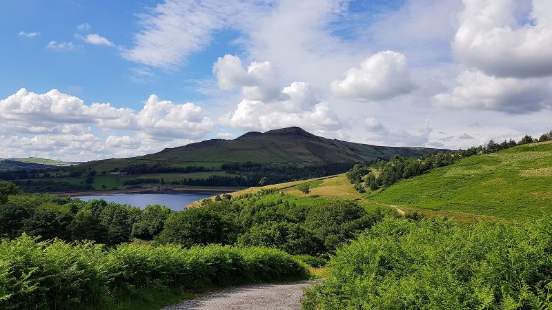
Not all of it is Oldham’s in the everyday sense. Part of the parish lies in the Peak District National Park, and part in the South Pennines Countryside Character Area. The moor walker sees the change. Countryfile describes a district of high moors, gritstone edges and a string of weaving hamlets.
Romans, monks and the four meres
The Pennines have blocked travel between east and west since Roman times. Around AD 79 the Romans built a fort in the Castleshaw valley, along Hull Brook, to guard the road from Chester to York. That road climbed over the hills at Standedge, at about 1,450 feet. Excavations have shown the Castleshaw site to be more complex than archaeologists once thought.
The next settlers to leave a mark came from the far side of the hills. In about 1250, Cistercian monks from Roche Abbey, near Rotherham, set up a farm on the grassy slopes of the Castleshaw valley. Roche lay about 30 miles away over the Pennines. Lunn takes that as proof that paths crossed the hills in the Middle Ages, since the monks needed one to get there.
The monks gave their name to a quarter of the district. After the Norman Conquest, Saddleworth became part of the Honour of Pontefract. It split into four “meres”, a word that means boundary: Friarmere, Shawmere, Lordsmere and Quickmere. Friarmere was the monks’ share, belonging to Roche Abbey. One of its divisions, Light Side, took in Castleshaw.
Lordsmere was the largest by far, the eastern block under the direct control of the lord of the manor. It held most of the places a visitor now knows: Diggle, Delph, Dobcross, Uppermill, part of Greenfield, and Saddleworth Moor. Quickmere’s Middle division took in Scouthead, Austerlands, Springhead, Grotton, Lydgate and Grasscroft. For a time the whole district also went by the single name “Quick”.
The meres were fixed long before today’s villages grew, so the old lines cut across them. The township itself is older still. The parish council traces it back to the Saxon period.
Those overlapping lines left Saddleworth unusually rich in boundary stones. The Yorkshire Milestones survey describes two kinds. One kind marks where Saddleworth met its neighbours, and the other marks the internal lines within it. There was plenty of both, because the district only became one administrative unit in 1937.
Saddleworth bordered 11 other townships. On the Mossley side, stones put up in 1885 survive on five roads into Saddleworth. In the Second World War, all of Mossley’s stones were defaced to confuse any invader. Where the A640 New Hey Road leaves Friarmere for Milnrow, a last stone still names the counties on each face. The mere names themselves outlived their purpose. By the 1890s they had no official role, yet they survive on milestones the County Council set up in that decade.
Victorian reforms added more lines. Springhead Urban District came first, in 1864, under the name Quickmere Middle. Uppermill got its own sanitary district in 1868, and a rural district covered most of the rest from 1876. Uppermill and the rural district merged in 1900 as Saddleworth Urban District, which absorbed Springhead in 1937. At either end of Uppermill on the A672, two stones still read “A ULB BOUNDARY” and “B ULB BOUNDARY”, left by the Uppermill Local Board.
The present civil parish dates from 1974, but its boundaries match the 1937 district almost exactly. The parish council argues that this long continuity gives people a strong sense of local identity, at parish level and in each village.
How roads, a canal and wool built the villages
Before the mills, Saddleworth people wove at home. The district holds many weavers’ cottages, with the workroom on the top floor. Long mullioned windows ran across those top floors to let in as much light as the loom needed. The walls were gritstone and the roofs were stone flags, both dug from the hills around them.
more
Wool drove the change that followed. The Saddleworth Historical Society traces it through the buildings: home weaving gave way to early water mills, and those gave way to large factories. The story runs from the late 18th century to the industry’s decline in Saddleworth in the mid 19th century. Scribbling mills went up across the last two decades of the 18th century. Most of those mills are gone, but many of their ponds remain.
The turnpikes
Roads came first, and roads made the villages. The historical society calls the district’s turnpike network second to none. The parish council ranks it among the most impressive in the country. Workers left the hillsides for terraced houses beside the mills, and the villages took shape along the new routes.
Delph shows the pattern plainly. It sits where Hull Brook meets the Tame, hemmed in by hills. A turnpike arrived in 1758, and the first houses went up along King Street. The road first crossed the river by a ford, until a bridge came in about 1770 and the village spread along High Street.
One early route had a famous surveyor. Countryfile names the pioneering road builder Blind Jack of Knaresborough as the man who surveyed the original turnpike over the moors near Marsden, in the 1760s. That road, Old Mount Road, still climbs out of Marsden today.
Dobcross rose first and lost its lead first. It sat on a hill at the end of Harrop Edge, at a crossroads of two routes through the district. By the late 18th century it was the main settlement in Saddleworth. The Swan Inn, built in 1765 as the King’s Head, held an assembly room upstairs. It was the district’s main meeting place until Uppermill built its Mechanics Institute. Dobcross raised the money for a church by 1787, and two banks opened on its square early in the 19th century.
Its roads were turnpiked in 1792 and 1806, but Uppermill was already overtaking it. In 1863 a new road bypassed Dobcross altogether. Theakstone notes that the centre has changed little since the late 18th century.
Uppermill had its own boost. In 1791 a group of local people bought the manorial rights of Saddleworth. One of them, John Buckley, built the Manor House on High Street, now the Conservative Club. Uppermill started to grow when the turnpike from Oldham to Standedge reached it in 1794. By the late 19th century it was a textile community.
The canal
Parliament heard the proposal for the Huddersfield Narrow Canal in 1793, and work began a year later. An Act of 1794 approved it. The canal linked the Ashton Canal to the Huddersfield Broad Canal.
The Woolroad basin, between Uppermill and Dobcross, opened in 1799. For ten years it was the end of the line on the western side, and goods moved there for the onward trip to Marsden. From Woolroad the canal leaves the Tame valley and climbs nine locks, the Diggle flight, with a waiting basin between each pair.
At the top lies the reason the job took 17 years. The Standedge Tunnel opened in 1811. It runs 3 miles 133 yards and is only 9 feet wide, the longest canal tunnel in Britain. The tunnel had no towpath, so boatmen “legged” the barges through. The horses walked over the top along Boat Lane, which Countryfile walkers still follow. The tunnel runs more than 600 feet below that lane. The parish council calls the canal one of the great engineering feats of its day.
Cheap slate came with the canal. Builders switched to it from stone flags, and Saddleworth’s roofs changed. The Saddleworth Independent blames the narrow width and the tunnel bottleneck for the canal’s poor trade. The Saddleworth Independent dates its closure to 1963, though Lunn’s walk gives 1944.
The railway and the mills
Railways finished the canal’s trade. At Uppermill the line crosses the Tame and the canal on a viaduct of 23 arches. The engineer AS Jee designed it with three skewed arches so the canal could pass beneath. The Manchester Railway company commissioned it, but by its completion in 1849 the firm had merged into the London and North Western Railway. At its northern end, Theakstone notes, the canal itself crosses above the river at the same point.
The mills that survive show every stage. Brownhill Bridge Mill, below Dobcross at Nicker Brow, dates from the 1770s. It is the oldest of the early mills to survive without drastic change. From outside it looks like a weaver’s house, with rows of mullioned windows. It ran on a water wheel, never on steam, and never employed more than a handful of people.
Diggle shows the later scale. A loom works built there in the 1860s employed more than 500 men in the 1890s. The woollen trade declined after the Second World War, and the Loom Works closed in 1969.
Growth brought shops and banks to the valley villages. In Delph, Number 8 King Street keeps the bow windows of a Georgian shop. The Delph Bank building opened in 1883 as the Manchester and County Bank. Uppermill got a picture palace in September 1913, with a Mr Chapman at the piano to accompany the films. The Methodist church on its square opened the same year, replacing a chapel about a century older.
The people who kept Saddleworth Yorkshire
Some of the district’s people keep its Yorkshire past alive on purpose. Since 1974, Lunn writes, campaigners have worked to keep Yorkshire symbols on show in Saddleworth. The white rose on Oldham Council’s own sign at Standedge is one of their wins.
The Saddleworth White Rose Society leads the effort. Its members campaign to have Saddleworth recognised as part of the West Riding. They also want to correct the belief that 1974 moved the district into Lancashire. In the two years before the Examiner’s report, the society marked several places where the Lancashire and Yorkshire line follows Saddleworth’s edge. Boundary signs went up on the A672, the A640, and the A669 at a spot named County End.
Geoff Bayley, the society’s chairman, argued from the calendar. The Ridings had existed for more than 1,000 years, he said, while the county councils that ran them lasted from 1889 to 1974. On his reading, 1974 abolished the councils, not the Ridings. Roy Bardsley, a founder member and the society’s secretary, saw the same point in a statement by the Local Government Secretary, Eric Pickles. Pickles had said the government would treat England’s historic counties as still existing.
Oliver Benson carries the Yorkshire flag at Saddleworth’s Yorkshire Day celebrations, held around August 1. Fifty years after the change, he told the Saddleworth Independent the district had never left the West Riding. He recalls a meeting in the building that is now the museum, where the vote on the move split three equal ways. As many people said it was moving as said it was not, and as many again abstained.
Benson has no time for Oldham’s praise. When the borough calls Saddleworth the jewel in its crown, he answers that Saddleworth was never Oldham’s. He says Saddleworth makes up 53 per cent of the area Oldham runs. He keeps a letter from 1900 addressed to “Uppermill via Oldham, West Riding of Yorkshire”. Oldham appears there, he explains, only because it had the nearest big post office.
He also sees the old identity fading. When the mills ran, he says, most residents worked locally and Saddleworth was an enclave. Fewer people now believe it belongs in Yorkshire, in his view, and new building near the old border blurs the line. Some residents, he says, would like Saddleworth, Meltham, Holmfirth and Marsden to form an area of their own.
The Yorkshire Day programme has its own routine. In the year the Examiner covered, it opened with a brass band in the Museum Gardens at Uppermill. Speeches and a reading of the Yorkshire Declaration followed, then a parade along High Street to the King George V playing fields for a country fair.
Sport keeps the eastern ties too. Delph plays cricket in the Drakes Huddersfield League. Football clubs from Uppermill, Diggle and Heyside play in the Huddersfield District League.
Older customs survive alongside the politics. Rushcarts began as a way to carry fresh rushes to the church floor. Once villages grew, the rushes came from further off, first on sledges and then piled on carts. The job turned into a festival, timed to the mill holidays known as wakes week. Horses pulled the carts until one bolted in Delph and its rider died. Teams of dancers in clogs took over the pulling, and every village built its own cart, each trying to outdo the rest. Morris men revived the custom in Saddleworth in the 1970s. The Saddleworth Independent’s John Kirkbride counts Saddleworth among the few places in Britain where it survives.
Other people stand out in the record. Jenny Lunn credits Mike Buckley of the Saddleworth Historical Society with corrections to her walk. Buckley also wrote the White Rose Society articles on the four meres that the boundary-stone survey drew on.
What a visitor finds today
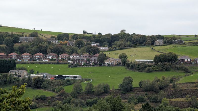
The mills went quiet, and the commuters arrived. In the second half of the 20th century, the parish council says, Saddleworth changed from industrial stone villages into a largely dormitory district. Its people now work in the big employment centres on both sides of the Pennines. The motorways sped that change up. Village shops and services declined, and housebuilding boomed, especially in the west.
more
Some of that building was careless. The historical society regrets mid to late 20th century work that ignored the area’s character and cost it many old buildings. New houses now usually go up in stone, and some borrow local details. The district holds 4 Grade II* buildings and 375 Grade II buildings and structures. Another 8 have lost their listing. Oldham Council and the Greater Manchester Archaeological Unit are also compiling a local list of buildings that the national list misses. Its entries include a telephone box at Weakey, the Diggle Mill weir, and the remains of a water wheel housing at Diggle New Mill.
Uppermill
Uppermill is where most visitors start. The Saddleworth Independent calls it the main village, partly because the Civic Hall there houses the parish council. Tourism now carries a share of its economy, with new bars and cafes opening. Saddleworth Museum and Gallery fills a restored mill from 1862, right beside the canal. It also houses a Tourist Information centre.
The canal is open again. The Huddersfield Canal Society formed in 1974 to restore it. The canal reopened to boats in 2001. At Wool Road, the Saddleworth Historical Society restored the Transhipment Shed’s structure between 1977 and 1983. The Canal Society took over in 1993 and finished the job.
Pubs anchor the old village. The Cross Keys has served drinkers since 1745. The Commercial, known locally as the Commie, has now taken that nickname as its name. Uppermill hosts the Rush Cart Festival and the Yanks weekend, and draws big crowds on Whit Friday.
Whit Friday is the brass band day. The contests fall on the first Friday after Pentecost. Organisers say the bands began in the 19th century, when local mill and factory owners founded them. Contests reached Uppermill a few years after 1884, the earliest date the Tameside organisers give. In a recent year, bands played at 11 venues across the Saddleworth and Oldham villages. Each band plays a march and a show piece for a judge who scores each band blind.
The Rushcart weekend falls on the August Bank Holiday. On the Saturday the procession tours villages including Uppermill, Greenfield, Delph and Dobcross. On the Sunday it ends in Uppermill Square before moving to the Church Inn and the Cross Keys.
The other villages
Delph keeps its turnpike-era street. The Swan Inn, from the late 18th century, holds the centre, and the post office keeps a Victorian shopfront. Number 8 Millgate is a three-storey building with warehouse doors.
Diggle wears its industry openly. The old Loom Works became offices, used most recently by W. H. Shaw’s pallet works. Theakstone records a fight over plans to build a new Saddleworth School on the site. A single road, Huddersfield Road, runs the length of the village and is usually congested. Beside the Diggle Hotel, three railway tunnel portals open into the hill, with the canal portal near the phone box.
On foot
Walking is the best way to read the place. Lunn’s Discovering Britain route follows the old ways over the hills from the Tame up to Standedge. For a short stretch it joins the Pennine Way, Britain’s first long-distance footpath. That trail opened in 1965 after a 30-year campaign and runs 251 miles. Two shorter trails cross the district: the 40-mile Oldham Way round the borough’s edge, and the 12-mile Standedge Trail joining the tunnel’s two ends.
Countryfile’s linear walk starts at Marsden station in Yorkshire and ends at Greenfield station. It crosses the National Trust’s Marsden Moor estate and climbs above Redbrook Reservoir to the Pennine Way. It drops down Boat Lane to Diggle, then reaches the soot-darkened St Chad’s Church at Pob Green. The route finishes along the towpath from Uppermill. Expect boggy patches and high summer nettles. Trains run back to Marsden from Greenfield until late evening.
From Uppermill, buses run to Oldham, Ashton, Manchester and Huddersfield. Greenfield station lies 1½ miles away, with an hourly train to Manchester or Huddersfield. The Guardian gives the trip to Manchester Victoria as 23 minutes, and 21 minutes the other way to Huddersfield. A resident it quoted recommends the walk round Dovestone Reservoir.
Starter guide
Visit these sights and walk these routes to see Saddleworth’s history on the ground:
- Standedge Tunnel (1811). The longest canal tunnel in Britain, at 3 miles 133 yards and only 9 feet wide.
- Castleshaw Roman fort. Built around AD 79 to guard the Chester to York road where it climbed to Standedge.
- Saddleworth Museum and Gallery. Local art, history and heritage in a restored 1862 mill beside the canal at Uppermill.
- Uppermill viaduct (1849). Twenty-three arches, three of them skewed by AS Jee to clear the canal.
- The Diggle flight. Nine locks lifting the canal from Woolroad to the tunnel mouth, with a waiting basin between each.
- Dobcross Square. The village centre has barely changed since the late 18th century, and the 1765 Swan Inn fills one side.
- Brownhill Bridge Mill (1770s). The oldest early water mill in Saddleworth to survive without drastic change, beside an old packhorse bridge.
- St Chad’s Church, Pob Green. Its graveyard holds the Bill o’ Jack’s tomb, a memorial to the victims of a murder in 1832.
- Saddleworth Rushcart Festival. Dancers haul a rushcart through the villages over the August Bank Holiday weekend.
- Saddleworth walk: South Pennines to Standedge (Jenny Lunn). A Discovering Britain route that reads the district’s roads, paths and canal as evidence of its past.
- Walk: Saddleworth Moor (Countryfile). A linear moorland walk from Marsden to Greenfield, over the old turnpike and down Boat Lane.
- Standedge Trail. A 12-mile path linking the two ends of the Standedge Tunnel over the top.