Lake Chad has lost nine-tenths of its surface area since the 1960s, through climate change, population growth and unplanned irrigation. The lake did not fade out slowly, either. Almost all of that loss happened by the 1990s, and then, by one detailed study, it stopped.
more
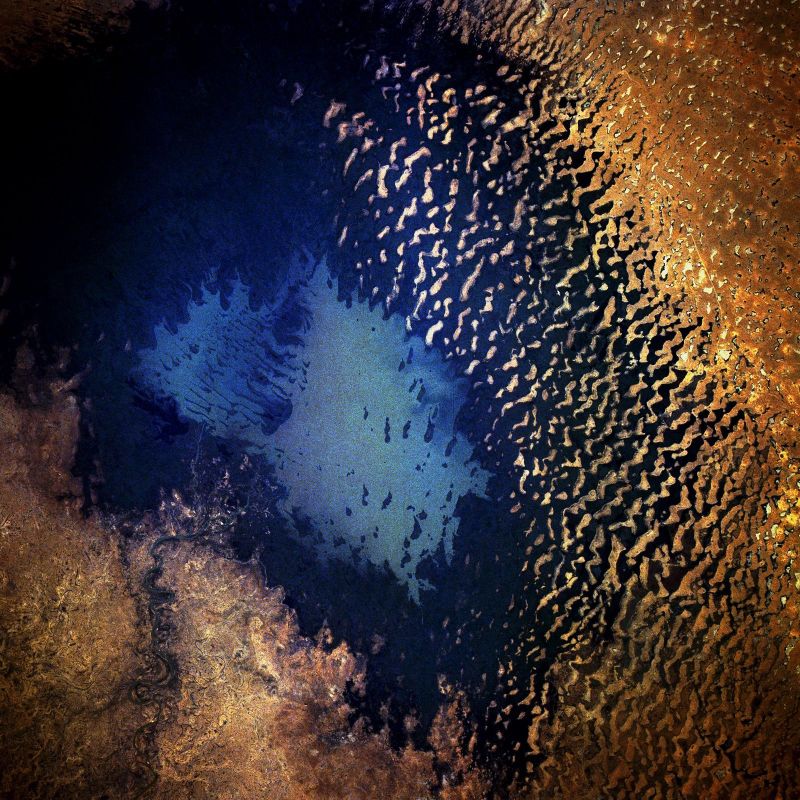
Start with what the lake looked like before the drop. A US reconnaissance satellite photographed it in 1963, and an Apollo 7 astronaut photographed it again in 1968. Both images show a single, unbroken body of water spanning at least 22,000 square kilometres, about the size of New Jersey. The French explorer Jean Tilho had reported parts of the lake dry as early as 1910, so the basin was never a stable pool.
Why the rains failed
Severe drought settled over the Sahel for more than a decade through the 1970s. Lake Chad depends on two main inflows: the Chari river, which arrives from the south, and the seasonal Komadugu-Yobe, which arrives from the northwest. Both rivers draw on rain that falls during a short West African monsoon season, from July to September, so a poor monsoon leaves the lake with less to replace what evaporates.
Doctoral research by Churchill Okonkwo, done at Howard University, traced the turning point to the late 1960s and early 1970s, when two ocean-linked climate cycles shifted at once. The Atlantic Multi-decadal Oscillation moved into what researchers call its cold phase, and that shift cut Sahel rainfall. Okonkwo’s team found the effect strong enough to cancel out the brief wet spells that La Niña years usually bring, and a strong El Niño in 1982 and 1983 added further dryness. Lake levels fell roughly three metres below the average recorded between 1900 and 2010, and by the 1980s the lake’s area had dropped to about 300 square kilometres, from a peak of about 22,000. Satellite images from 1973, 1976 and 1979 track the collapse. By 1976 the lake had split into a northern and a southern basin, divided by a shallow sill called the Great Barrier. The two lobes have never rejoined.
The part people played
Drought was not acting alone. Population growth around the basin and a rapid expansion of unplanned irrigation drew down water that would otherwise have reached the lake. The US Geological Survey lists rising water use alongside drought as a direct cause of the shrinkage.
Geography made the lake unusually exposed to both pressures at once. Lake Chad was never deep: its floor sits so close to the surrounding land that the basin has rarely held more than about seven metres of water, even at its fullest. Because the lake spread wide rather than sitting deep, a fall in inflow cost it a large share of its surface area. As the shoreline retreated, people farmed the newly exposed lakebed and drew on what remained, adding to a lake that already had the least water to give. By 1982, a shuttle photograph caught sand dunes forming on ground the lake had abandoned, pushed into shape by winds blowing from the northeast.
Did Lake Chad keep shrinking after that?
Here the record complicates the popular version of the story. A two-year study by Oli Brown of Chatham House and Janani Vivekananda of the think tank Adelphi found that Lake Chad’s average size has been stable since the 1990s, and by some measures has grown. The US Geological Survey’s own account agrees: it describes the lake’s water levels as having “stabilized in recent years,” while still calling it a dynamic environment.
Brown and Vivekananda’s point is not that the lake recovered. It is that the 90% figure describes a real collapse between the 1960s and the 1990s, and gets repeated as though the lake has kept vanishing ever since, which their data does not support. They call the ongoing-decline version a “doubly convenient narrative,” because it draws attention away from governance failures in the region and builds a case for an expensive engineering fix. Warming has not stopped, and the two researchers put the pace of local temperature rise at one and a half times the worldwide figure. Their argument is narrower than a denial of climate change: the lake itself is not currently shrinking, even though the region’s climate risks are real.
Why the lake got tied to Boko Haram
The shrinking-lake narrative carries weight because it is also used to explain the region’s violence. Bale Bura fished on the lake as a boy in the 1970s, and today he represents fishing crews there through their trade association. He remembers boats crowding the water and fish markets doing brisk trade, against farmland that has since gone largely idle. The account commonly told from testimony like his runs in a straight line: the lake shrank, fishing and farming work disappeared, and jobless young men joined Boko Haram instead.
Brown and Vivekananda reject the straight line to a shrinking lake, pointing instead to poverty, sectarian mistrust, political marginalisation and corruption as the harder problems. Bura himself names the same pull: he knows people from his own village who took what he calls “ugly kinds of jobs” with the militants. The BBC report that carries his account adds that poor governance, not the lake alone, has also driven the violence. Both accounts agree that people are suffering. They disagree on what would fix it.
That disagreement matters because a fix is already on the table. In 1982, the Italian engineering firm Bonifica Spa proposed Transaqua, a 2,400-kilometre canal that would carry water from tributaries of the Congo river to the Chari river basin and on into Lake Chad. The engineer who worked the numbers, Marcello Vichi, sent 500 copies of the finished plan to African governments and international lenders in 1985. He recalls the reply as “a deafening silence.” Renewed alarm over Islamist militancy and migration brought the idea back at a conference in Abuja, where Bonifica and PowerChina, which helped build the Three Gorges Dam, agreed to a feasibility study, and backers set out to raise $50 billion for the project. Nigeria and the African Development Bank are still pursuing that funding. Whether a 2,400-kilometre canal is worth building for a lake that a careful study says stopped shrinking thirty years ago is the question the project’s backers have yet to answer.